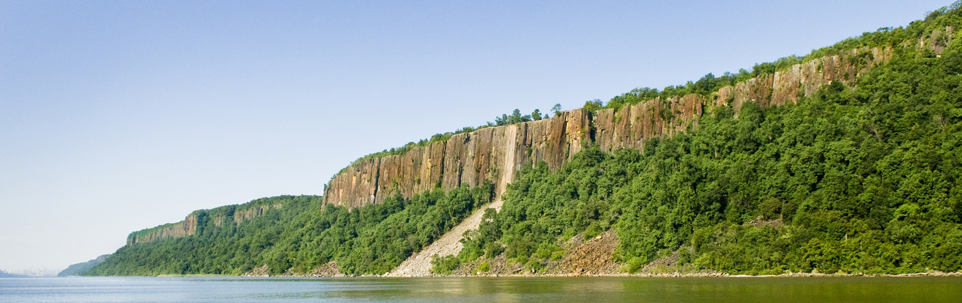
New York and New Jersey came together to form the Palisades Interstate Park Commission in 1900. It was the culmination of years of effort to preserve the famous Palisades Cliffs from several large quarries that were blasting them for crushed stone and building material.
Carpenter Brothers’ quarry in fort Lee, c. 1900.
Photo courtesy of the Lamb family | PIPC archives.
The quarries were in New Jersey, but the outcry against them had begun across the river in New York — where each day millions could see the devastation the quarries caused. The first concerted effort to preserve the Palisades, in the 1890s, had been led by the American Scenic and Historic Preservation Society, which was based in New York City. The Society at last found an ally on the Jersey side of the river in 1895, when the New Jersey State Federation of Women’s Clubs joined the fight. The women set out to persuade the state legislature to pass a bill to join with New York to protect the Palisades. By 1900 New Jersey Governor Foster Voorhees was able to sign just such a bill. The same year, in New York, a similar bill also passed and was signed by Governor Theodore Roosevelt. Vital financial support came from J. P. Morgan, who donated over $125,000 to close the Carpenter Brothers’ Quarry in Fort Lee, the largest and most notorious of the Palisades quarries.
On September 27, 1909, at “the old Cornwallis Headquarters” (today known as the Kearney House ) at Alpine Landing, the governors of New York and New Jersey dedicated the Palisades Interstate Park, officially opening it to the public. The event was part of a region-wide celebration that marked the 300th anniversary of Henry Hudson’s 1609 voyage up the river that would be named for him — learn more about this event in “Beyond the Reach of Devastation .”
Photo: PIPC archives.
While the Palisades riverfront in 1900 (the year the Interstate Commission was formed) had many wild characteristics, it was not untouched wilderness. As early as the mid-1700s, a few hardy families had begun to homestead along the rocky shoreline, at a handful of river landings. These landings took advantage of natural breaks in the cliff face — mountain passes — through which farmers on the west side of the Palisades could build wagon roads to the Hudson to ship their goods to New York City’s marketplaces. These “roads” in turn probably followed old Indian trails, from which nearby tribes had set up seasonal encampments on the riverbanks to fish and to trade with other tribes.
In November 1776 a British Army led by General Cornwallis used the New Dock at Lower Closter Landing (later named Huyler’s Landing) to attack and capture Fort Lee — prompting Washington’s famous “Retreat to Victory” across the Jerseys. As the Revolution went on for the next seven years, the river landings were used by armies and raiding parties as they moved between British-occupied New York City and the beleaguered “Neutral Ground” of the surrounding countryside.
“Invasion of the Jerseys” — 225th anniversary reenactment, 2001.
Photo: Anthony Taranto.
During the 1800s, the isolated river landings grew into thriving communities of boatmen, laborers, and their families. By mid-century dozens of small quarries had been established to mine the “trap-rock” of the talus slope beneath the cliffs — used for building docks in New York and Brooklyn — which in turn helped fuel an economic boom along the Palisades. Men of the river landings continued to fish for shad each spring and to serve as captains and crew on the sloops and schooners that plied the river. But now steam-powered “bone factories,” where animal bones were grinded for fertilizer, joined the talus quarries along the shore, while the docks at Alpine Landing were expanded to accommodate a big steam-powered cereal mill. Immigrant laborers came to work in the quarries and the factories, to join the already diverse communities at the landings.
Catherine “Kitty” Brown, a descendent of enslaved Bergen County residents, at the home she shared with her siblings at Huyler’s Landing beneath the Palisades in the late 1800s.
Image courtesy of John Spring | PIPC archives.
New in 2024: Our public historians have created an online archive of documents relating to the Miles family, which operated the large riverfront mill at Alpine. Click here to explore these resources.
The mid-century economic boom at the river landings was long past by 1900, when the Palisades Interstate Park Commission was created. Big industrialized quarry operations now blasted sections of the cliffs. Still, there were several hundred people living in what was about to become a park, among them some whose families had lived here for generations. In the decade leading up to the 1909 dedication, the newly formed Interstate Commission set out to buy their homes and properties to create this new public “playground.” Some of the river folk would stay, to rent their homes from the Commission, and some even took jobs in the new park. But a way of life along the river was coming swiftly to an end.
Bathing beach in the new park, circa 1915.
Photo: PIPC archives.
From as early as the 1860s, some families along the Palisades had leased “excursion groves” to companies that ran steamboat outings from the city. Typically, a couple thousand “excursionists” took a sail up the river, stopped for a few hours at a grove — to picnic, dance, perhaps to play baseball or some other game — and then sailed back to the city. The Commission sought to continue and expand this kind of activity. Workers improved old excursion areas and built new ones. They added modern amenities like city water and police protection. The earliest and largest such park area was at Forest View , at the northern end of the park, with wide lawns, a ball field, campgrounds, a pavilion with a beer garden, and later, a boat basin.
Steamer Warwick at Twombly’s Landing, 1931.
Photo: PIPC archives.
Beginning in 1912, to accommodate the automobile — still a relatively new feature of American life — the Commission began construction of Henry Hudson Drive , a unique “motor trail” through the park. Around the same time, the Commission built ferry approach roads and docks for a pair of large vehicular ferry services. One operated from Dyckman Street in Manhattan to Englewood Landing, the other from Yonkers to Alpine Landing. Boat basins were built at both ferry landings, along with picnic groves and other amenities.
By 1930, these two ferry lines, together, transported over a million vehicles across the river each year. Along with a passenger-only boat that ran to Hazard’s Dock from 158th Street, they also brought many thousands of visitors to and from the park each nice summer day.
A ferry departs from Alpine Boat Basin for Yonkers, circa 1932. Learn more about this unique ferry operation in “Skirt Check ”!
Photo: PIPC archives.
From the outset, the biggest attraction in the new park was river bathing. Besides the beaches at the ferry landings, a big stone bathhouse was built for a beach at Hazard’s Dock at the southern end of the park in 1918, another big bathhouse was built for Undercliff Beach in 1922, and around the same time a “camp colony ” was established at Ross Dock, with its own small beach.
Through much of the Great Depression of the 1930s, attendance at the park and its beaches soared, as millions took advantage of inexpensive recreation just a ferry ride from home. Get a better sense of our bathing beaches — and their eventual demise — in “The ‘Mystery’ of the Beaches. ”
Photo: PIPC archives.
Also during the Depression, the park benefitted from “New Deal” work agencies, including the Civil Works Administration (CWA), which in 1934 built bathhouses at the Alpine and Bloomer’s beaches (the bathhouse at Alpine is still in use today as Alpine Pavilion); the Works Progress Administration (WPA); and the Civilian Conservation Corps (CCC), which operated out of a pair of camps at Greenbrook .
“CCC boys” building retaining walls along Henry Hudson Drive in 1937.
Photo: PIPC archives.
Many factors — the improving economy, the opening of the George Washington Bridge (which spelled doom for most of the ferry lines), America’s entry into the Second World War —and, finally, river pollution — led to the closing of the last Palisades beach, at Alpine, after the 1943 season.
From Colonial days through the first half of the nineteenth century, the summit of the Palisades, with its thin soil and acres of exposed bedrock, held little attraction for farmers or land speculators. Lumberjacks harvested the forests for firewood and building material, “pitching” logs to the river using natural chutes — “pitching places” — formed by crevasses in the cliffs. But only a few dozen rugged individuals and families, most of them living on the economic margins, built homes on the summit early on. Among them was a community of free Black families led by Jack Earnest, a man who started life enslaved to a local farmer but who bought his own freedom and founded a settlement known as “Skunk Hollow ” near the state line in the early 1800s.
The Palisades summit in winter.
Photo: Ken Habermann.
It wasn’t until around the time of the Civil War that the Palisades summit got “discovered” as a site for summer homes.
Among the first New York families to establish a “country seat” — a vacation home — on the Palisades was that of Joseph Lamb, founder of J.&R. Lamb Studios, one of the most prominent stained glass studios in the country. The Lamb family built “Falcon Lodge” near today’s Tenafly-Alpine border around 1860.
Photo courtesy of the Lamb family | PIPC archives.
Col. Sweeting Miles established a big cereal mill at Alpine Landing. He chose “Pulpit Rock,” overlooking the mill, to build his elegant home. Charles Nordhoff, an author and newspaper editor, built an estate nearby (it’s said that it was Mrs. Nordhoff who first proposed the name “Alpine” for the area), as did J. Cleveland Cady, the architect who designed Nordhoff’s home (and who also designed the beautiful stone Community Church at the top of Closter Dock Road, still in use). On the Englewood cliffs, William and Catherine Dana, he an editor and publisher, she an author, built “Graycliffs.” By the early 1870s a north-south road, called the Boulevard, was laid across the summit, and the Danas and others financed the construction of an opulent cliff-edge hotel in Englewood Cliffs.
“The Palisades Mountain House” could accommodate around five hundred guests in fine luxury, and the owners built a spectacular carriage road to a steamboat landing on the river (the park would later modify this road to become Dyckman Hill Road). The Mountain House burned in 1884 , but grand estates continued to be built along the Boulevard.
Image courtesy of Edwin Rizer | PIPC archives.
The creation of the Palisades Interstate Park Commission in 1900 would at first have little effect on the estates. It was reasonably assumed that the Commission would confine its efforts to the riverfront.
Among the twentieth-century arrivals to what was to become known as “Millionaire’s Row” were Dr. Ernest Cadgene, a French chemist who operated silk mills in Paterson, and who built his estate in Englewood Cliffs, near today’s Rockefeller Lookout; Manuel Rionda, “the Sugar Baron,” who owned sugarcane plantations in Cuba, and who built the sprawling “Rio Vista,” largest of the Palisades estates, its manor house where Alpine Lookout is today (the wrought iron fencing still along the cliff edge there is from Rio Vista); his nephew, Manuel E. Rionda, who would be mayor of Alpine, and who built “Glen Goin” (named for his wife, Ellen Goin) on the old Nordhoff estate; John and Mable Ringling, of circus fame, who built “Gray Crag ” farther north in Alpine — before moving to an even grander estate in Sarasota; John Clawson and Cora Timken Burnett, a scientist and an artist — and heiress to the vast Timken fortune — who designed a bizarre and secluded estate on an isolated section of cliff top in Alpine; George A. Zabriskie, a flour merchant and amateur historian, who built a new and grander “Cliff Dale ” (his summer home!) on the former grounds of W. C. Baker’s estate of the same name; and the Oltmans, who built “Penlyn ,” now our Park Headquarters.
“Cliff Dale” manor house (hand colored sepia-toned photo).
Photo courtesy of John Spring | PIPC archives.
While most of its activity indeed focused on the riverfront, on the summit in Englewood Cliffs, the Park Commission established a “tourist camp” for early motor campers…
... while on the stone precipices above the Fort Lee bathing beaches, early movie makers were busy cranking out classic silent “cliffhangers …!” Historic image of filming on the Palisades in 1918 courtesy of the Fort Lee Film Commission . Present-day image: Anthony Taranto.
In April 1929, on top of the Palisades in Alpine, a long delayed monument , in the shape of a miniature watchtower, was dedicated to the role the New Jersey State Federation of Women’s Clubs had played in preserving the Palisades.
Photo: PIPC archives.
At the same time they were honoring the creation of this unique Interstate Park, however, the Commissioners were wrestling with a new challenge. Just months earlier, ground had been broken for a bridge from Fort Lee to Manhattan. Named the George Washington Memorial Bridge when it opened in October 1931, its construction raised a serious question: What was to become of the summit of the Palisades, once it had been made accessible to every automobile in New York City?
Construction of the new “Hudson River Bridge” (later named the George Washinton Bridge) from the park in Fort Lee, c. 1930.
Photo: PIPC archives.
The Commission had a strong — and at first, secret — ally in the person of John D. Rockefeller Jr., who began quietly to buy up as much of the property on the summit as he could. He would donate several hundred acres to the Commission in 1933, with the stipulation that the Commission use this land to build a scenic parkway from the new George Washington Bridge to the Bear Mountain Bridge — and that all man-made structures visible from across the river be removed.
The days of the grand cliff-edge estates were coming to a sudden end.
The Works Progress Administration (WPA) was given the task of surveying the route of the Parkway — and of razing the “undesirable structures” along the cliff edge. Here they are beginning to raze “Gray Crag ,” the former estate of John and Mable Ringling in Alpine.
Photo: PIPC archives.
During this time, the WPA also built a unique refreshment stand at “Point Lookout ,” the highest point on the Palisades, a stand that is still in operation today!
Photo: PIPC archives.
The Second World War delayed the start of the construction of the Palisades Interstate Parkway , and there was some significant opposition to the new highway from conservationists, who felt it would needlessly mar the summit. The Commission however held fast to its conception of a limited-access scenic highway on the summit, as opposed to simply widening 9W, with its weight of commercial traffic, as most of the Parkway’s opponents proposed. (Though it didn’t appease all opponents of the Parkway, a compromise of sorts was reached through the creation of Greenbrook Sanctuary .)
Construction of the Palisades Interstate Parkway began in New York in 1947, in New Jersey in 1948. A “demonstration mile” for the public opened in Englewood Cliffs in 1950. The final section in New Jersey was completed in Alpine on June 22, 1957. On August 28, 1958, the final five-mile section in New York, between Tappan and Nanuet, was opened to traffic. Over 60,000 cars now use the Parkway each day.
A “Demonstration Mile” of the Palisades Interstate Parkway was opened to motorists in Englewood Cliffs to try out in 1955.
Photo: PIPC archives.
In 1965, the United States Department of the Interior and the National Park Service designated the Palisades Interstate Park a National Historic Landmark, noting, “The Palisades Interstate Park represents an unusual effort by two states, New Jersey and New York, to preserve the scenic beauty of the cliffs on the lower western side of the Hudson River…”
Around that time, efforts were taken to preserve “the Bluff” in Fort Lee, where the Continental Army had placed its batteries in 1776. The site was eventually acquired by the Commission, which opened Fort Lee Historic Park in time for the American Bicentennial in 1976. An innovative school program was soon after developed at the site, and continues today.
Photo: Crossroads of the American Revolution National Heritage Area.
In 1971, both the Long Path and the Palisades Shore Trail were designated as National Recreation Trails.
Photo: Anna Gordon.
In 1983 “The Palisades of the Hudson” was designated a National Natural Landmark, as “the best example of a thick diabase sill formation known in the United States. Columnar jointing, an olivine zone and thermal metamorphic effects are attributes found in rare combination at this site. The glaciated crest provides impressive evidence of the Pleistocene glacier.”
Around the same time, the historic Kearney House was added to the New Jersey State and National Historic Registers (listed as “Blackledge-Kearney House”). In 1990, after decades of being closed, it was restored and reopened to the public.
Photo courtesy of C. F. William Maurer | PIPC archives.
In the late 1990’s Ross Dock Picnic Area was renovated, and a hawk watch was established at State Line Lookout .
Photos: Anthony Taranto (top), Liam Keegan (bottom).
In 1998 the Palisades Interstate Parkway was designated as a National Landmark by the National Park Service.
Further renovation of the Kearney House was done in 2003, with the fireplaces brought back into use a year later, allowing for a new “living history ” approach to programming there. Other interpretive programming was also developed throughout the park at this time, and a new park map (download ) was developed.
Photos: Anthony Taranto.
Many challenges remain — among them, rebuilding after Hurricane Sandy, which devastated our riverfront in the fall of 2012 — but this park has fully entered its second century. As we noted at the end of an article published in 2009, on the centennial of the park’s dedication: “Beaches and campgrounds, bathhouses and CCC camps — picnic groves and boat basins and a ‘tourist camp’ — much has come and gone. ... Yet beyond even the great cliffs themselves, something vital persists: a promise made, a promise to be kept...”
Centennial of the dedication of the Palisades Interstate Park, September 27, 2009.
Photo: Anthony Taranto.